Tuesday, May 18, 2021

Bikation day 6 - Petaluma to Davis

The ride from Petaluma to Davis ended up being 91 miles with 3500' of climbing. Everything started well with the ride from Petaluma to Napa being through gently rolling wine country with lovely roads and light traffic. We somehow managed to ride all the way through Napa without seeing a coffee shop (poor route design on my part) and had to stop at a 7-11 just before we left Napa. I really don't like 7-11's, partly because they won't let you use the restroom.

After Napa we headed north on highway 121 which quickly turned into a steep, winding climb with no shoulder and heavy traffic - pretty much the definition of a death trap. I used the ridewithgps mobile app to find a safer route to Davis. I had never used this feature before but it took me less than a minute to find a safe route. I sent them a thank-you note.

After more miles over rolling hills and through scenic vineyards we got to Manker Corner just as a small café was opening (this happened a lot). We had a sandwich and soda, they filled our water bottles, and we kept riding.


After a while we found ourselves on the same route the Davis Double used to use to get us home. Roads started becoming familiar again and we found ourselves back in Davis at the impeccable Quality Inn. We were done.

Bikation day 5 - Gualala to Petaluma

I don't know why, but I had a hard time pronouncing Gualala and Petaluma so every time someone asked us where we had started or where we were going today, I sounded like I had a speech defect. Today we rode 76 miles from Gualala to Petaluma with 6100' of climbing. The first fifty miles was similar to the previous day, with a low of 46F (51 degrees cooler than the high on day two), spectacular scenery, lots of climbing, and no shoulder.


We had lunch (or was it second breakfast) at the Fort Ross store. One thing we constantly found in the small communities that only had one store is that the stores were excellent, with high quality produce and a wide selection. We never had to look far for good food.


At Bodega Bay we did a little off-roading before heading inland on the steepest, roughest, most wonderful road of the ride. At the base of the inland section we met three retired gentlemen who gave us some local advice and proceeded to trounce us up the climb (me, not Amber)

Here's some of the off-road part.


Here's some of the climbing that was rougher than the off-road!


A few miles inland we ate at the Casino bar in Bodega - a rough and ready bar run by a lady with a grill and a great attitude.

Casino bar and grill

At Petaluma, Amber found a great Japanese restaurant where we had a well deserved dinner. Gotta love Yelp.


Bikation day 4 - Fort Bragg to Gualala

 Day four saw us ride down the California coast from Fort Bragg to Gualala for 60 miles and 4500' of climbing. I don't understand why the fifth largest economy in the world can't put a decent bike lane on its premier bike route. We just want 24" in each direction. If Caltrans can find the funds to put a 20' wide road in, would another four feet really be that difficult? Mind you, the scenery is amazing and once we were ten miles south of Fort Bragg, the traffic was fairly light.


Yesterday's gale force southerly winds had died down to a mild breeze and the overcast kept the temperature to around 50F for most of the day with the high well below 70F. We had lunch at a small store in Elk which opened just as we got there.


It was very hilly so we had some gnarly downhills.


We stayed at the Gualala Country Inn for the overnight which was quite pleasant. Gualala is a small town with several motels, restaurants, and a store. Walking the beach path after eating was a good way to stretch out the legs.


Bikation day 3 - Willits to Fort Bragg

Day three was originally planned to be a 70 mile ride from Willits to Fort Bragg starting with 25 miles along the 101, crossing over some hills to the 1, then 20 miles south on the 1. However, the previous day on the 101 was so unpleasant that we decided to simply ride 35 miles on highway 20 from Willits to Fort Bragg. Ridewithgps,com did not want to route us on the 20 at all and riders were posting very negative reviews of the road. On the other hand, whenever I looked at the road with Google street level, it looked better than the 101. After a lot of research we decided to take the 20 over to Fort Bragg. The rwgps app created a route for us to follow. Love that new feature.

Highway 20 had some spectacular views and quite a lot of climbing, but it was more downhill than up.
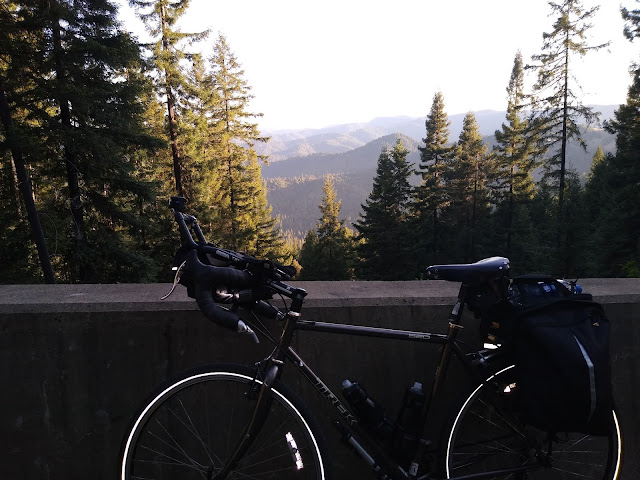
Highway 20


Just as we got to Fort Bragg Amber's rear derailleur cable snapped which was good timing because we had just finished a ton of climbing and we were only a mile from Fort Bragg Cyclery where Mark was ready to fix it for us. Plus there was a coffee shop next door while we waited.

Mark is awesome

Once we got the bike fixed we headed over to the Skunk Train station and purchased some tickets for the 2pm train.

A lady at the Willits Expresso stand had recommended we visit the Pomo cliffs so we headed there while waiting for the train. There was a powerful southerly wind while we were there. Guess which way we were headed tomorrow?

Pomo cliffs


After viewing the cliffs we had some lunch, then headed up to the Skunk Train for a 90 minute trip inland and back. There's only 3.5 miles of restored track, but it was a lot of fun and the train was surprisingly full for mid-week.


Skunk train

After 30 minutes (yes, the train travels at 7mph but at least it left on time, unlike Amtrak) we arrived at the turn around which has some lovely hiking trails. We were able to walk around for 30 minutes before the train left.

Hiking trail at the Skunk turnaround

Once the train returned us to Fort Bragg we were able to check into our room at the Anchor Lodge which is down in the harbor area. We got a ground floor, river view room with a balcony. This was the view from the room.

View from motel room

This was the first motel to offer breakfast which was delivered in a brown paper bag.

Breakfast

There's a lot of places to eat down at the harbor. I assume all these buildings used to be fish processing and net making businesses that have closed down and been repurposed. One of them advertised fish and chips so we decided to give it a try. They had outside seating which was very scenic but the seagulls were pretty bold.

Don't turn your back


All in all this was my favorite day.


Monday, May 17, 2021

Bikation day 2 - Cloverdale to Willits

Day 2 of our bikation was 56 miles from Cloverdale to Willits with 2700' of climbing, most of it towards the end. The predicted temperature was up to 96F but the wind was quieter than yesterday.

We started by wandering through vast vineyards on quiet, smooth roads. Wonderful.


Our first stop was a country store in Talmage which was a mistake because Ukiah was just around the corner with a much bigger selection. The store had a small Mexican food counter in it where a lovely lady made me a veggie burrito and Amber a cheese quesadilla.

Talmage Store

Shortly after Ukiah we started riding on the shoulder of the 101 which was awful. Some idiot Caltrans employee had put the rumble strip right in the middle of the shoulder, making it largely unusable. Here's a video of the descent to the Willits exit.


Willits is a nice small town with an expresso stand which Amber saw first. It was a pleasant surprise.

Brewed Awakening

The Super-8 here was a little better but they were still playing the no laundry, no breakfast scam despite charging a ridiculous amount for a room. I really must stop using Super-8. I think they've got even worse since being bought up by Wyndham.

While we were waiting for our laundry we ate dinner at El Chicano - I highly recommend it.

Bikation day 1 - Davis to Cloverdale

Amber and I just finished a six day tour of northern California. We rode 410 miles with about 25,000' of climbing while fully loaded. I was riding my Trek 520 touring bike with rack, rack bag, and panniers. Amber rode her Lynskey, also with rack, rack bag, and panniers.

We started in Davis and rode up to Cloverdale. It was almost 100 miles with 4300' of climbing. Unfortunately California decided to have a heat wave so we were looking at a high of 93F with 20 mph winds from the NNW. We started at 5am so we would complete the serious climbing before it got too hot. It worked pretty well except for the 200' kicker at mile 70 which was grueling.

We followed the Davis Double route for a while and our first stop was in Winters where we found a nice coffee shop was just opening. Coffee and a breakfast sandwich was wonderful.

Winters Coffee Shop

Our route took us West for the first 25 miles and the cross wind was so strong at times it seemed the only thing stopping the wind from blowing us over was the weight of the panniers. After that we turned Northwest which meant we had more of a headwind which was much safer.


Our next stop was at the Turtle Rock café which is in the perfect spot on a long gentle climb. Again, we got there just as they were opening. It's like they knew we were coming.

Turtle Rock café

We stopped in Calistoga for some Thai food. We stayed away from the spicy stuff because we still had 30 miles to go and we didn't know where the restrooms were. We soon picked up the 128 which is like twenty miles of cattle grid. I thank Amazon I had 35mm tires. It improved slightly after Geyserville (I pronounced it Geezerville). We took the last ten miles to Cloverdale nice and easy.

We got to the Super-8 about 3pm. There's nothing super about this motel. Like many of the bad motel chains, they're using the pandemic as an excuse to reduce services while at the same time increasing prices. Of the seven motels we stayed at, three were still advertising breakfast but not serving it, three were serving breakfast, and one didn't ever offer it. We had similar results with laundry.